Magazine
Before Central Park: A Brief History in 10 Fun Facts
In 1853, all of Manhattan’s dedicated green space added up to fewer than 200 acres—a pittance compared to London’s 6,000 acres and unfitting for a quickly growing city with dreams of being one of the world’s great metropolises. The solution was Central Park.
Today, Central Park is such an iconic part of New York that it’s easy to forget that millions of years of history happened on this ground before the Park’s first trees were planted in 1858. In her new book, Before Central Park, Conservancy Historian Emerita Sara Cedar Miller traces the history of the “pre-Park,” from prehistoric glaciers to the Revolutionary War to Seneca Village and beyond. Keep reading for 10 fascinating takeaways that you can also take with you on your next excursion into the Park.
1. ERRATIC LANDSCAPES
2.5 million to 11,000 years ago
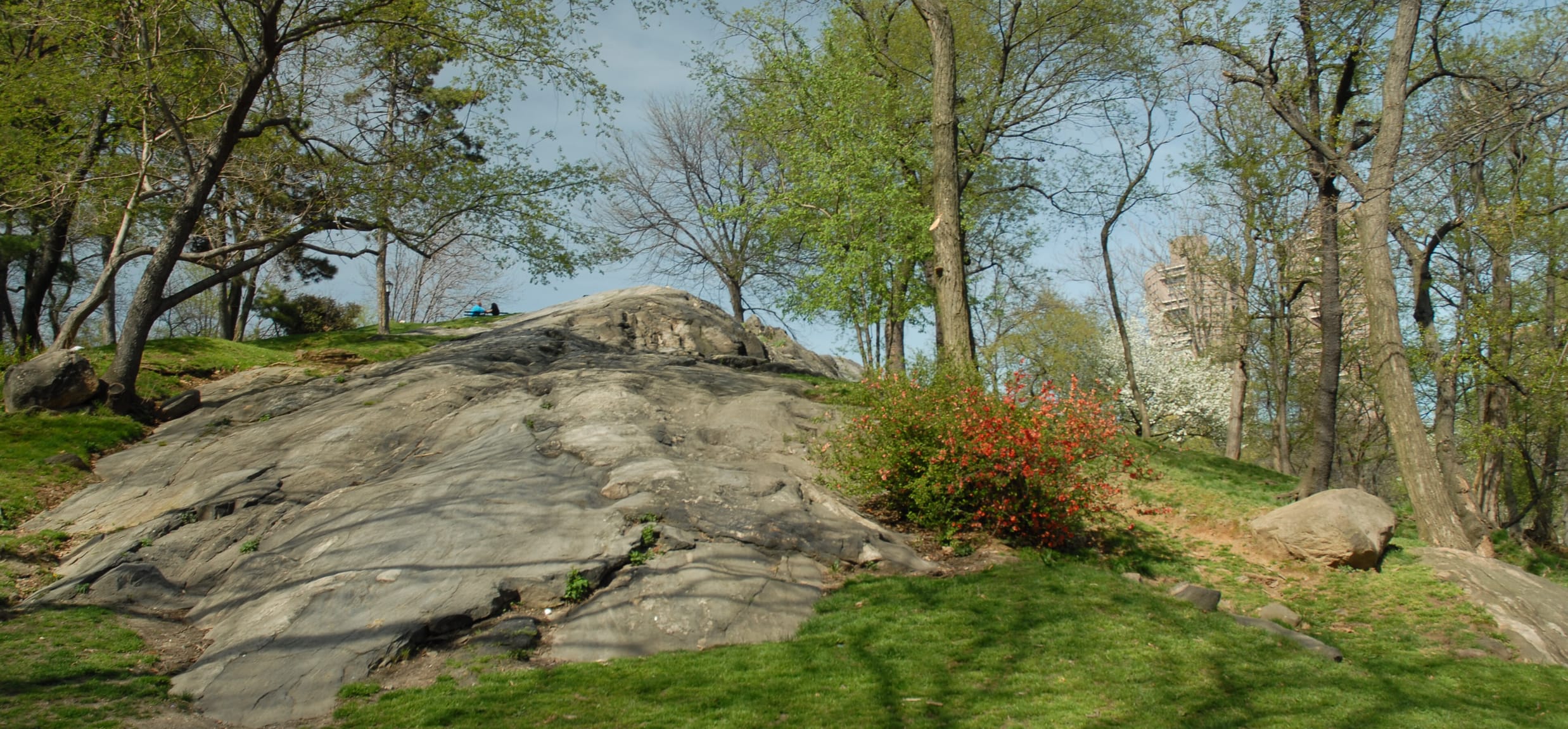
During the last ice age, a glacier known as the Laurentide ice sheet covered not only Manhattan but most of the northern United States and Canada. At its peak (roughly 20,000 years ago), the ice sheet was two miles thick. As the glacier receded, it sculpted the topography of Manhattan Island, carving out the deep valleys of the Hudson and East Rivers and leaving an undulating, hilly landscape in its wake. It also chiseled deep grooves in the area’s rocky outcrops and left behind massive boulders, known as “glacial erratics.”
When work on Central Park began in the 1850s, many of these boulders were used to build retaining walls throughout the Park. Others were used as eye-catching natural sculptures, including a line of erratics that can now be seen in the southeast corner of Sheep Meadow.

A view of Sheep Meadow, with glacial erratics of various sizes
2. TRAIL-BLAZERS
Before the 17th century
The Lenape peoples who inhabited Manhattan before the arrival of Europeans enjoyed an island of great bounty. Up north was fresh water and fertile land. To the south there were excellent hunting and fishing grounds. The 14-mile Wickquasgeck Trail (later renamed the Kingsbridge Road) ran between the two areas and crossed the northeast corner of the pre-Park.
Curious to follow the old Wickquasgeck Trail’s route across the Park? Start at Engineers’ Gate at East 90th Street and head up the East Drive to McGowan’s Pass (look for Fort Clinton on the Conservancy’s maps). At that point, the road would have crossed what is now the Harlem Meer before continuing north.

Passing through McGowan’s Pass, the Kingsbridge Road was so steep that carriages sometimes overturned coming down it. It remains a dramatic and beautiful piece of the Park’s topography.
3. LITTLE LONDON
1776
On September 15, 1776, the British army attacked Manhattan. Sailing five warships up the East River, they turned 80 cannons on the few hundred scantily armed Revolutionary soldiers stationed at Kip’s Bay. The rebels hastily retreated.
The British then established themselves on the island, including across the northern portion of the pre-Park. They would have a continuous presence on the island for the next seven years—and New York would come to be the second largest British city in the world, after London.
4. A FIGHTING CHANCE
1812 and after
The Revolutionary War ended in 1783, but fighting between the mighty British army and their former American colonists would continue. During and after the War of 1812, American soldiers constructed a series of fortifications around McGowan’s pass, including Fort Clinton, Nutter’s Battery, Fort Fish, and the Blockhouse. (Only the Blockhouse, located in the North Woods, still stands today.) Dive deeper into this fascinating pre-Park story with our self-guided Fort Landscapes Tour.
5. STREET DIRT
Early 19th century
British and Dutch settlers viewed the middle of Manhattan as inhospitable to agriculture and thus worthless. But after the Revolutionary War, the cash-strapped City began to sell off this land to interested investors.
One such investor was James Amory, who in the early 1800s transformed an area that now includes the Mall, Bethesda Terrace, the Dene, and Rumsey Playfield into a thriving farm. He grew gooseberries, currants, raspberries, wheat, oats, corn, potatoes, and even a grove for timber.
What turned this formerly “worthless” area into such healthy farmland? In large part, the compost is created from “street dirt”—cow and horse manure collected from the City’s streets. In fact, this manure was valuable enough that by 1830, the Common Council had set standardized prices and hired inspectors to keep records of this asset.

Bethesda Terrace—once part of James Amory’s 70-acre farm
6. SENECA VILLAGE
1825–1857
On September 17, 1825, the landowner John Whitehead sold 27 lots of land to five members of New York’s A.M.E. Zion Church, and Seneca Village was born. A community of almost exclusively free Black citizens, the Village housed some 200 residents and counted around 50 homes, three churches, burial grounds, and a school by 1855.
For Black New Yorkers, owning a piece of property in Seneca Village, located near the Park’s current West 85th Street entrance, helped them achieve a major civic milestone: suffrage. According to the law, any man in New York who owned property valued at $250 or more was eligible to vote, regardless of race. Of the Black New Yorkers registered to vote in 1845, one quarter of them were in Seneca Village.
Moreover, for Black New Yorkers, Seneca Village offered a welcome respite from the racism, overcrowding, and disease of the lower parts of the island. For the same reason, many immigrants gravitated toward this community, and while almost all of the landowners in Seneca Village were Black, it’s estimated that after 1855, a portion of the residents (many of whom rented their plots) were Irish and German, too.
7. BIG BELFAST
circa 1850
It wasn’t just Seneca Village; the entire pre-Park was home to large immigrant communities. Its south end, around the Hallett Nature Sanctuary, Heckscher Playground and Fields, and Wollman Rink, was home to numerous piggeries run by Irish and German immigrants. A community of German immigrants also resided in the area that’s now the East Meadow and North Meadow. In fact, by around 1850, New York had more Irish citizens than either Dublin or Belfast, and only Berlin and Vienna had more Germans.
8. ANGEL OF THE WATERS
1837–1842
Cities need fresh water to survive, but this urban necessity can result in complex infrastructural headaches in a city as densely populated and as quickly expanding as mid-19th-century New York. Enter the Croton Aqueduct, built between 1837 and 1842 to bring water from the Croton River to the City. A large distributing reservoir had already been built on Fifth Avenue, where the main branch of the New York Public Library now stands, but a second reservoir—designed to receive incoming water—was needed. Forty blocks uptown, between Sixth and Seventh Avenues and reaching from 79th to 86th Streets, engineers built a reservoir capable of holding 180 million gallons of water.
Park visitors may be surprised to realize that this receiving reservoir was not the Reservoir we see today, which was built as an expansion of the original reservoir some years later. Instead, the original receiving reservoir stood on the site of today’s Great Lawn.

A 1927 photograph of Manhattan. The original (rectangular) reservoir is visible just underneath the later reservoir at the center of the image.
Irma and Paul Milstein Division of United States History, Local History and Genealogy, The New York Public Library. "General view - [Manhattan - Central Park and surrounding area.]" New York Public Library Digital Collections.
9. SWEET TREAT
Mid-19th Century
In the early days of Central Park, the building that’s now Tavern on the Green housed the sheep who grazed at nearby Sheep Meadow. But before the Park’s establishment, a nearby area played a role in one of 19th-century New York’s most important industries: sugar refinement.
There is nothing sweet about the refinement process. In the 19th century, sugar cane was mostly grown in the Caribbean and Central and South America, where a vast enslaved population was used for the backbreaking harvest. The raw cane, ground into a dark slurry, was then shipped to America for processing.
To turn sugar slurry into crystals, refiners poured it through a fine powder of animal bone, acquired by boiling carcasses and then incinerating the bones. The boiling process smelled horrible, beginning with the pile of carcasses awaiting their turn in the cauldrons. The City (unsurprisingly) declared the bone-boiling establishments unsanitary and an affront to gentility and relegated them to the outskirts of town—including to the area where the Tavern on the Green now stands.

Today, the beautiful historic structure of the Tavern on the Green houses a restaurant overlooking the Park.
10. THE SISTERS OF CHARITY OF MOUNT ST. VINCENT
1847
Concerts have been part of Central Park’s programming since 1859, the first year the Park was open to the public. But pre-Park land was also home to musical traditions. In 1847, for instance, the Sisters of Charity of Saint Vincent de Paul moved from the southern end of the island to a homestead on what is today the Mount, and that November, they hosted a concert at their new premises.
In 1856, the Sisters built a new chapel on their property, which they believed would be “the gem of [Manhattan] island”—only to be informed a few months later that the land had been requisitioned for the construction of the Park. The Sisters moved to the border of the Bronx and Yonkers (to what is today the College of Mount Saint Vincent), but the chapel remained standing until it burned down in 1881.
Kamala Schelling is the Conservancy’s Senior Marketing Writer & Editor.


